

Following the significant March–April 2025 flood event across western Queensland, Bulloo Shire Council engaged SHEPHERD to rapidly assess flood damage across its remote road network and prepare evidence to support Disaster Recovery Funding Arrangements (DRFA) submissions.
Focusing initially on Innamincka Road and other priority areas, SHEPHERD combined rapid RACAS® network capture, field inspection and damage assessment to give Council an early, evidence-based picture of the damage and accelerate the pathway from assessment to funding submission. A priority $1.8 million submission was assessed and lodged within five days, with 96% approved within one month.
The Challenge
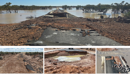
Bulloo Shire covers approximately 73,724 square kilometres, with a population of around 350 people and a road network spread across an extremely remote operating environment.
The March–April flood event caused widespread disruption across the region. At Thargomindah, the flood exceeded the previous record, with the river estimated to have reached 7.5 metres after overtopping the official gauge board. The event caused widespread inundation and extended periods of isolation.
For Council, the challenge was not simply identifying damaged roads. It needed to establish the location, extent and severity of damage quickly enough to support priority DRFA submissions, while working across a vast and difficult-to-access network.
Speed mattered, but so did the quality and traceability of the evidence.
The Solution
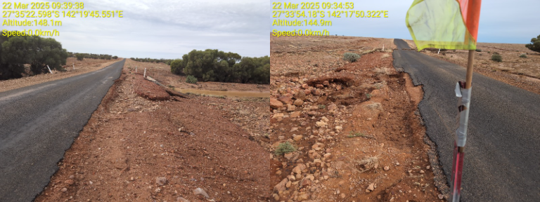
SHEPHERD deployed a highly targeted assessment team supported by RACAS® to rapidly capture road condition and flood damage across priority areas of the Shire.
In just seven days, 1,056 kilometres of roads were surveyed using RACAS®.
The assessment identified 2,515 Points of Interest and 831 damage sites across just 25% of the Shire, with more than $11 million in damage identified at that stage of the recovery program.
All of this was achieved using a field team of just two inspectors and one damage assessor.
Key outcomes included:
- 1,056 km of roads RACAS® surveyed in seven days
- $1.8 million priority submission assessed and lodged within five days
- 96% approval achieved within one month
- 2,515 Points of Interest identified
- 831 damage sites identified across 25% of the Shire
- more than $11 million in flood damage identified
- delivery using just two inspectors and one damage assessor.
What We Did Differently and Why It Mattered
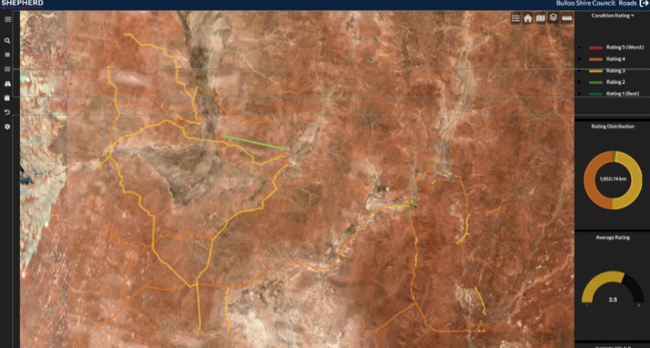
The priority was to move from flood impact to defensible evidence as quickly as possible.
Rather than relying on a slow, road-by-road manual assessment process, RACAS® enabled large sections of the network to be captured rapidly, while inspectors and assessors focused their effort on identifying and validating damage.
This efficient resource model meant Council could establish the scale of damage quickly without deploying a large inspection team across an enormous geographic area.
The Innamincka Road submission demonstrated the practical value of that approach. A $1.8 million submission was picked up, assessed and lodged within five days, and 96% was approved within a month.
The result was a faster line of sight from field evidence to damage assessment to funding submission, helping Council progress recovery sooner while maintaining the records required to support DRFA assurance and acquittal.
Across the broader $53 million recovery program, $49 million was assessed and submitted within six months, with 76% of the priority submission delivered within eight months. This helped turn rapid assessment into practical recovery on the ground sooner.
Delivered in Partnership
Delivering recovery works in one of Queensland’s most remote shires brings challenges well beyond damage assessment.
Accommodation, communications, water supply, construction materials, procurement and contractor availability all needed to be considered as the program moved from assessment into delivery. The recovery response included practical solutions such as Starlink connectivity, local contractor engagement and planning around significant haul distances for sealing aggregates.
Working alongside Bulloo Shire Council, SHEPHERD combined practical disaster recovery experience with rapid road data capture and engineering assessment to help Council move quickly from understanding the damage to securing funding and progressing delivery.
The Innamincka Road response shows what can be achieved when the right technology, experienced people and a clear assessment process come together: 1,056 kilometres surveyed in seven days and a $1.8 million submission lodged within five days—with a team of just three people.